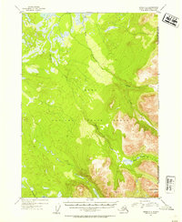
1952 Map of Kenai C-1
USGS Topo · Published 1954About this map
The Kenai National Moose Range dominates this mid-century topography, showing the wilderness transition where the Chugach National Forest boundary meets the interior wetlands of the Kenai Peninsula. The Chickaloon River and Mystery Creek wind through a landscape defined by glacial lakes and muskeg, providing a clear record of the area's hydrology before later development. Human presence is sparse, marked only by an isolated Cabin in the north and primitive transit routes. Early backcountry access is documented through the Seven Lakes Trail and a Ski-Mobile Trail near the southern shore of Jean Lake. Rising above the river valleys, Round Mountain serves as a prominent landmark in the southeastern corner, anchoring a region of sharp relief and complex drainage systems including Thurman Creek and Dike Creek.
Find a feature on this map
13 named features on this map. Tap any name to fly to it.
Don’t see what you’re looking for? This feature index may not catch every label — zoom into the map to look around manually.
Map Details
Editions of this 1952 Kenai C-1 Map
2 editions found

Other maps of this area

1944 · Kenai
USGS Topo · 1:250,000

1950 · Kenai
USGS Topo · 1:250,000

1950 · Kenai B-1
USGS Topo · 1:63,360

1951 · Seward
USGS Topo · 1:250,000

1951 · Kenai B-2
USGS Topo · 1:63,360

1951 · Kenai C-1
USGS Topo · 1:63,360

1951 · Kenai C-2
USGS Topo · 1:63,360

1951 · Kenai D-1
USGS Topo · 1:63,360

1951 · Kenai D-2
USGS Topo · 1:63,360

1951 · Seward C-8
USGS Topo · 1:63,360