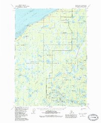
1951 Map of Kenai D-2
USGS Topo · Published 1986About this map
Cook Inlet defines the northwestern reaches of this coastal wilderness, where Tidal Flats and a prominent Shoal meet the shoreline at Moose Point. The 1950s landscape is characterized by a dense network of freshwater bodies within the Kenai National Wildlife Refuge, including named features such as Kenaitze Lake, Bill Besser Lake, and Kuguyuk Lake. A lone Pipeline traverses the northern terrain near Birth Hill, signaling early industrial infrastructure amidst the wetlands.
Find a feature on this map
106 named features on this map. Tap any name to fly to it.
Don’t see what you’re looking for? This feature index may not catch every label — zoom into the map to look around manually.
Map Details
Editions of this 1951 Kenai D-2 Map
3 editions found
Other maps of this area

1944 · Kenai
USGS Topo · 1:250,000

1949 · Tyonek
USGS Topo · 1:250,000

1950 · Kenai
USGS Topo · 1:250,000

1950 · Kenai C-3
USGS Topo · 1:63,360

1951 · Tyonek
USGS Topo · 1:250,000

1951 · Kenai D-3
USGS Topo · 1:63,360

1951 · Kenai C-1
USGS Topo · 1:63,360

1951 · Kenai C-2
USGS Topo · 1:63,360

1951 · Kenai D-1
USGS Topo · 1:63,360

1951 · Kenai D-2
USGS Topo · 1:63,360