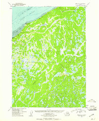
1952 Map of Kenai D-2
USGS Topo · Published 1961About this map
The Kenai National Moose Range dominates this landscape on the Kenai Peninsula, characterized by a complex network of thousands of small lakes and ponds interconnected by the Swanson River. In the early 1950s, this region remained largely untouched by major development, with the exception of scattered Cabins near the shoreline of Cook Inlet and along the shores of larger water bodies like Vogel Lake. Along the northern coast, Tidal Flats extend out from Moose Point, while the interior terrain rises toward Birch Hill. The presence of Homestead Entry Survey markings, such as HES No 144 and HES No 138, indicates the early stages of formal land claims in this wilderness. This map captures the intricate drainage patterns of Miller Creek and Otter Creek before the expansion of roads and infrastructure into the heart of the peninsula.
Find a feature on this map
26 named features on this map. Tap any name to fly to it.
Don’t see what you’re looking for? This feature index may not catch every label — zoom into the map to look around manually.
Map Details
Editions of this 1952 Kenai D-2 Map
4 editions found

Other maps of this area

1944 · Kenai
USGS Topo · 1:250,000

1949 · Tyonek
USGS Topo · 1:250,000

1950 · Kenai
USGS Topo · 1:250,000

1950 · Kenai C-3
USGS Topo · 1:63,360

1951 · Tyonek
USGS Topo · 1:250,000

1951 · Kenai D-3
USGS Topo · 1:63,360

1951 · Kenai C-1
USGS Topo · 1:63,360

1951 · Kenai C-2
USGS Topo · 1:63,360

1951 · Kenai D-1
USGS Topo · 1:63,360

1951 · Kenai D-2
USGS Topo · 1:63,360