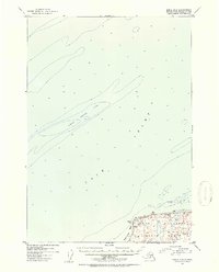
1952 Map of Kenai D-4
USGS Topo · Published 1954About this map
Cook Inlet dominates this mid-century hydrographic and topographic study, revealing the shifting bathymetry of the northern Kenai Peninsula waters. The central feature is the expansive Middle Ground Shoal, a significant navigational landmark detailed with numerous soundings that indicate the complex underwater terrain of the era. Along the shoreline, the map identifies Nikishka Bay and Boulder Point, providing a glimpse into the coastal geography before major industrial development.
Find a feature on this map
8 named features on this map. Tap any name to fly to it.
Don’t see what you’re looking for? This feature index may not catch every label — zoom into the map to look around manually.
Map Details
Editions of this 1952 Kenai D-4 Map
3 editions found

Other maps of this area

1944 · Kenai
USGS Topo · 1:250,000

1949 · Tyonek
USGS Topo · 1:250,000

1950 · Kenai
USGS Topo · 1:250,000

1950 · Kenai C-3
USGS Topo · 1:63,360

1950 · Kenai D-4
USGS Topo · 1:63,360

1951 · Tyonek
USGS Topo · 1:250,000

1951 · Kenai D-3
USGS Topo · 1:63,360

1951 · Kenai C-4
USGS Topo · 1:63,360

1951 · Kenai C-3
USGS Topo · 1:63,360

1952 · Kenai D-3
USGS Topo · 1:63,360