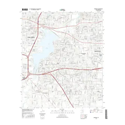
2016 Map of Kennedale
USGS Topo · Published 2016About this map
Lake Arlington dominates the center of this landscape, its western shores bordering Fort Worth and its eastern banks reaching into Pantego and Arlington. This 2016 survey captures the dense suburban growth of the Mid-Cities region, showing the evolution of older communities like Kennedale and Forest Hill. Significant historical markers remain amidst the modern developments, including Johnsons Station and the Tate Cem near Tate Springs. To the north, the historic community of Handley sits near the Handley Cem, while Arlington Baptist Coll is situated further east. The map provides a detailed view of the complex creek systems, such as Village Creek and Rush Creek, which flow through heavily residential areas and public spaces like Dalworthington Gardens. To the south, Birk Airport and Murray Hill mark the transition toward the less concentrated developments of Sublett.
Find a feature on this map
35 named features on this map. Tap any name to fly to it.
Don’t see what you’re looking for? This feature index may not catch every label — zoom into the map to look around manually.
Map Details
Editions of this 2016 Kennedale Map
This is the sole edition of this map. No revisions or reprints were ever made.
Other maps of this area

1894 · Fort Worth
USGS Topo · 1:125,000

1931 · Grapevine
USGS Topo · 1:62,500

1954 · Dallas
USGS Topo · 1:250,000

1955 · Haltom City
USGS Topo · 1:24,000

1955 · Burleson
USGS Topo · 1:24,000

1955 · Fort Worth
USGS Topo · 1:24,000

1955 · Haltom City
USGS Topo · 1:62,500

1958 · Dallas
USGS Topo · 1:250,000

1959 · Kennedale
USGS Topo · 1:24,000

1959 · Arlington
USGS Topo · 1:24,000