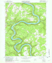
1963 Map of Kennerdell
USGS Topo · Published 1982About this map
The Allegheny River carves a deep, serpentine path through Venango County, defining the industrial and natural landscape of this 1963 survey. Extensive oil wells and named oil fields are scattered across the uplands, particularly near Siefer and Ajax Run, reflecting the region's enduring petroleum heritage. The infrastructure of the Conrail line follows the river's contours, punctuated by the notable Kennerdell Tunnel near the settlement of Kennerdell.
Find a feature on this map
59 named features on this map. Tap any name to fly to it.
Don’t see what you’re looking for? This feature index may not catch every label — zoom into the map to look around manually.
Map Details
Editions of this 1963 Kennerdell Map
4 editions found
Other maps of this area

1907 · Foxburg
USGS Topo · 1:62,500

1908 · Foxburg
USGS Topo · 1:62,500

1909 · Franklin
USGS Topo · 1:62,500

1910 · Hilliards
USGS Topo · 1:62,500

1911 · Franklin
USGS Topo · 1:62,500

1912 · Hilliards
USGS Topo · 1:62,500

1922 · Oil City
USGS Topo · 1:48,000

1924 · Oil City
USGS Topo · 1:62,500

1943 · Oil City
USGS Topo · 1:62,500

1944 · Hilliards
USGS Topo · 1:62,500
Featured Places
- Cranberry Township, PA
- Franklin, PA
- Rockland Township, PA
- Sandycreek Township, PA
- Scrubgrass Township, PA