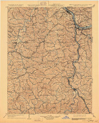
1903 Map of Kenova
USGS Topo · Published 1930About this map
Ashland and Catlettsburg anchor the northern reaches of this tri-state survey, where the Ohio River meets the Big Sandy River in a complex network of industrial and transport corridors. The landscape is defined by its strategic river forks and the heavy infrastructure of the era, specifically the Chesapeake and Ohio RR and the Norfolk and Western RR which weave through the valleys and over ridges. This 1903 edition, with updates reflecting the early 1900s, documents a period of significant regional growth driven by these transit hubs. Notable engineering features like the Means Tunnel and the convergence of Tug Fork and Levisa Fork at the border highlight the importance of water and rail movement. Numerous smaller settlements and local landmarks, from South Point to Westmoreland, are carefully noted alongside drainage features like Sawmill Br and Twelvepole Creek, providing a detailed picture of the region's geography before later 20th-century developments.
Find a feature on this map
197 named features on this map. Tap any name to fly to it.
Don’t see what you’re looking for? This feature index may not catch every label — zoom into the map to look around manually.
Map Details
Editions of this 1903 Kenova Map
5 editions found

Other maps of this area

1886 · Prestonsburg
USGS Topo · 1:125,000

1887 · Warfield
USGS Topo · 1:125,000

1889 · Salyersville
USGS Topo · 1:125,000

1891 · Salyersville
USGS Topo · 1:125,000

1891 · Warfield
USGS Topo · 1:125,000

1892 · Prestonsburg
USGS Topo · 1:125,000

1892 · Huntington
USGS Topo · 1:125,000

1898 · Huntington
USGS Topo · 1:125,000

1898 · Ironton
USGS Topo · 1:62,500

1899 · Salyersville
USGS Topo · 1:125,000