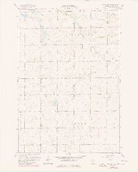
1958 Map of Kerkhoven SW
USGS Topo · Published 1980About this map
Shakopee Lake and the wetlands of the upper Chippewa River basin dominate this agricultural landscape, recorded during a 1958 survey with later updates. The map reveals a rural community structured around township lines and small social hubs, specifically in the jurisdictions of Louriston, Crate, Grace, and Havelock. Local centers of gravity are represented by the Buffalo Lake Ch, Zion Ch, and the Township Cem, which provided essential spiritual and civic anchors for the surrounding farmsteads. The terrain is marked by numerous small depressions and a network of drainage, reflecting the post-glacial topography of the region. This 1958 data, photorevised in 1977, preserves a specific moment in Minnesota's rural history before larger-scale modern industrial farming further consolidated these landholdings.
Find a feature on this map
9 named features on this map. Tap any name to fly to it.
Don’t see what you’re looking for? This feature index may not catch every label — zoom into the map to look around manually.
Map Details
Editions of this 1958 Kerkhoven SW Map
3 editions found

Other maps of this area

1953 · New Ulm
USGS Topo · 1:250,000

1953 · Saint Cloud
USGS Topo · 1:250,000

1957 · Saint Cloud
USGS Topo · 1:250,000

1957 · New Ulm
USGS Topo · 1:250,000

1958 · New Ulm
USGS Topo · 1:250,000

1958 · Saint Cloud
USGS Topo · 1:250,000

1958 · Murdock
USGS Topo · 1:24,000

1958 · Gracelock NE
USGS Topo · 1:24,000

1958 · Kerkhoven SE
USGS Topo · 1:24,000

1958 · Kerkhoven
USGS Topo · 1:24,000