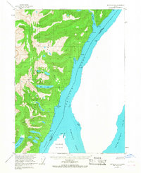
1955 Map of Ketchikan A-1
USGS Topo · Published 1967About this map
The international maritime boundary between the United States and Canada defines this 1955 survey of the rugged Alaska panhandle. Steep coastal topography characterizes the Tongass National Forest, where heavy-timbered slopes rise abruptly from the deep waters of the Portland Canal and Pearse Inlet. Notable peaks such as Dome Mountain and Stripe Mountain dominate the skyline above complex glacial and fluvial features like the Harrison Lakes and the Tidal Flat at Hidden Inlet.
Find a feature on this map
31 named features on this map. Tap any name to fly to it.
Don’t see what you’re looking for? This feature index may not catch every label — zoom into the map to look around manually.
Map Details
Editions of this 1955 Ketchikan A-1 Map
2 editions found
Other maps of this area

1951 · Prince Rupert
USGS Topo · 1:250,000

1952 · Ketchikan
USGS Topo · 1:250,000

1955 · Ketchikan A-2
USGS Topo · 1:63,360

1955 · Ketchikan A-1
USGS Topo · 1:63,360

1955 · Ketchikan B-2
USGS Topo · 1:63,360

1955 · Ketchikan B-1
USGS Topo · 1:63,360

1955 · Prince Rupert D-2
USGS Topo · 1:63,360
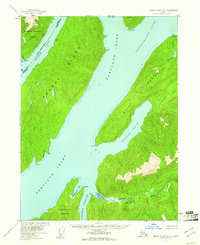
1955 · Prince Rupert D-1
USGS Topo · 1:63,360

1955 · Ketchikan
USGS Topo · 1:250,000

1959 · Prince Rupert
USGS Topo · 1:250,000