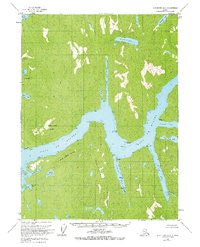
1955 Map of Ketchikan A-3
USGS Topo · Published 1967About this map
Boca De Quadra dominates this coastal survey, serving as the central waterway for a complex network of glacial fjords and deep-water inlets within the Tongass National Forest. The geography is defined by steep maritime terrain, where North Quadra Mountain and South Quadra Mountain flank the entrance to the main channel. To the north, Badger Bay and Weasel Cove carve deep into the landmass, while to the south, Mink Bay and Vixen Bay illustrate the intricate coastline of the Revillagigedo Islands region.
Find a feature on this map
32 named features on this map. Tap any name to fly to it.
Don’t see what you’re looking for? This feature index may not catch every label — zoom into the map to look around manually.
Map Details
Editions of this 1955 Ketchikan A-3 Map
3 editions found
Other maps of this area

1949 · Ketchikan B-4
USGS Topo · 1:63,360

1951 · Prince Rupert
USGS Topo · 1:250,000

1952 · Ketchikan
USGS Topo · 1:250,000

1952 · Ketchikan B-4
USGS Topo · 1:63,360

1955 · Ketchikan A-2
USGS Topo · 1:63,360

1955 · Prince Rupert D-3
USGS Topo · 1:63,360

1955 · Ketchikan A-4
USGS Topo · 1:63,360

1955 · Ketchikan B-2
USGS Topo · 1:63,360
1955 · Prince Rupert D-4
USGS Topo · 1:63,360

1955 · Ketchikan A-3
USGS Topo · 1:63,360