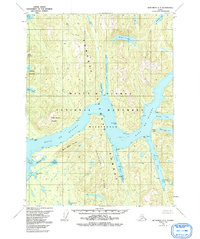
1955 Map of Ketchikan A-3
USGS Topo · Published 1992About this map
The Boca de Quadra fjord system dominates this coastal wilderness, carving deep into the mainland of Southeast Alaska within the Tongass National Forest. Mapped in the mid-1950s, the terrain shows the dramatic geological features of the Misty Fiords National Monument (Wilderness) long before its formal monument designation. The landscape is defined by steep elevation gains, rising from the waters of Badger Bay and Vixen Bay to the heights of Peninsula Ridge and South Quadra Mountain. This area is characterized by its complex hydrography, where inland freshwater bodies like Hugh Smith Lake and Kah Shakes Lake sit in close proximity to the saltwater channels of the Behm Canal. The intricate network of coves and inlets, including Weasel Cove and Bullhead Cove, illustrates the maritime-dependent geography of the region during this era.
Find a feature on this map
28 named features on this map. Tap any name to fly to it.
Don’t see what you’re looking for? This feature index may not catch every label — zoom into the map to look around manually.
Map Details
Editions of this 1955 Ketchikan A-3 Map
3 editions found
Other maps of this area

1949 · Ketchikan B-4
USGS Topo · 1:63,360

1951 · Prince Rupert
USGS Topo · 1:250,000

1952 · Ketchikan
USGS Topo · 1:250,000

1952 · Ketchikan B-4
USGS Topo · 1:63,360

1955 · Ketchikan A-2
USGS Topo · 1:63,360

1955 · Prince Rupert D-3
USGS Topo · 1:63,360

1955 · Ketchikan A-4
USGS Topo · 1:63,360

1955 · Ketchikan B-2
USGS Topo · 1:63,360
1955 · Prince Rupert D-4
USGS Topo · 1:63,360

1955 · Ketchikan A-3
USGS Topo · 1:63,360