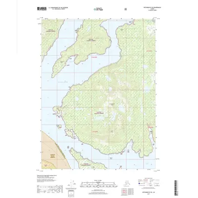
2017 Map of Ketchikan B-5 SE
USGS Topo · Published 2017About this map
Revillagigedo Island dominates this 2017 survey, showcasing a landscape defined by the deep inlets and rugged coastlines of Southeast Alaska. Most of the land falls under the protection of the Tongass National Forest, while the southern portion reveals the boundary of the Annette Island Reserve. Human infrastructure is sparse, concentrated primarily along the S Tongass Highway in the northwest, which traces the shoreline near Carroll Point. The map illustrates a maritime-dependent geography where named coastal features like California Cove and Moth Bay serve as primary points of orientation. Elevations rise sharply from the water to peaks such as Black Mtn and Black Mountain, emphasizing the verticality of the coastal fjords. Inland, Trap Lake sits as a solitary water body amidst the dense forest, while numerous small islands like Cynthia Island and Bold Island dot the surrounding waters of the Gulf of Alaska and Thorne Arm.
Find a feature on this map
27 named features on this map. Tap any name to fly to it.
Don’t see what you’re looking for? This feature index may not catch every label — zoom into the map to look around manually.
Map Details
Editions of this 2017 Ketchikan B-5 SE Map
This is the sole edition of this map. No revisions or reprints were ever made.
Other maps of this area

1949 · Ketchikan B-4
USGS Topo · 1:63,360

1952 · Ketchikan
USGS Topo · 1:250,000

1952 · Ketchikan B-4
USGS Topo · 1:63,360

1954 · Ketchikan B-5
USGS Topo · 1:63,360

1955 · Ketchikan A-4
USGS Topo · 1:63,360

1955 · Ketchikan A-5
USGS Topo · 1:63,360

1955 · Ketchikan
USGS Topo · 1:250,000

1955 · Ketchikan B-5
USGS Topo · 1:63,360
1991 · Ketchikan B-5 SW
USGS Topo · 1:25,000
1991 · Ketchikan B-5 NW
USGS Topo · 1:25,000