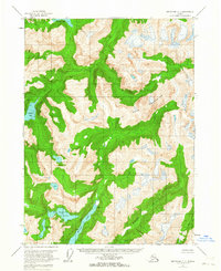
1955 Map of Ketchikan C-2
USGS Topo · Published 1963About this map
The Adam Mountains dominate this 1955 survey of the Alaskan wilderness within the Tongass National Forest. This high-altitude landscape is defined by its dramatic hydrography, featuring deep glacial basins and interconnected waterways. Notable water bodies include Walker Lake, Big Goat Lake, and Wilson Lake, which feed into the rugged drainage systems of the Blossom River and Keta River.
Find a feature on this map
10 named features on this map. Tap any name to fly to it.
Don’t see what you’re looking for? This feature index may not catch every label — zoom into the map to look around manually.
Map Details
Editions of this 1955 Ketchikan C-2 Map
2 editions found
Other maps of this area

1952 · Ketchikan
USGS Topo · 1:250,000

1955 · Ketchikan C-3
USGS Topo · 1:63,360

1955 · Ketchikan D-2
USGS Topo · 1:63,360

1955 · Ketchikan C-2
USGS Topo · 1:63,360

1955 · Ketchikan B-2
USGS Topo · 1:63,360

1955 · Ketchikan D-3
USGS Topo · 1:63,360

1955 · Ketchikan B-1
USGS Topo · 1:63,360

1955 · Ketchikan D-1
USGS Topo · 1:63,360

1955 · Ketchikan B-3
USGS Topo · 1:63,360

1955 · Ketchikan C-1
USGS Topo · 1:63,360