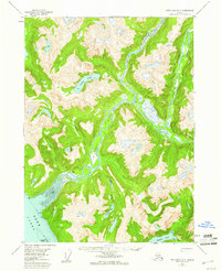
1955 Map of Ketchikan D-3
USGS Topo · Published 1960About this map
The Chickamin River and Leduc River valleys dominate this mid-century survey of the Tongass National Forest wilderness. The map documents a landscape defined by dramatic glacial valleys and tidal waters, where the Behm Canal meets the mainland at Fish Pt and Trap Pt. Settlement is sparse, represented only by isolated structures like Wolf Cabin and a lone Cabin situated near the confluence of Humpy Creek. This 1955 field-annotated map provides a look at the region's complex drainage systems, including high-altitude features like Leduc Lake and Heart Lake. In the southwest, the expansive Tidal Flat and the Channel Islands illustrate the transition from mountain runoff to the saltwater inlets of Walker Cove. The data reflects a pre-industrial era of the Alaska Panhandle, primarily serving as a record of the natural terrain and essential seasonal shelters.
Find a feature on this map
20 named features on this map. Tap any name to fly to it.
Don’t see what you’re looking for? This feature index may not catch every label — zoom into the map to look around manually.
Map Details
Editions of this 1955 Ketchikan D-3 Map
3 editions found

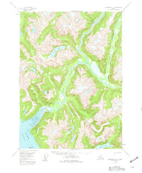
Other maps of this area

1951 · Bradfield Canal
USGS Topo · 1:250,000

1952 · Ketchikan
USGS Topo · 1:250,000

1952 · Ketchikan C-4
USGS Topo · 1:63,360

1954 · Bradfield Canal
USGS Topo · 1:250,000

1955 · Ketchikan C-3
USGS Topo · 1:63,360

1955 · Ketchikan D-2
USGS Topo · 1:63,360

1955 · Bradfield canal A-4
USGS Topo · 1:63,360

1955 · Bradfield canal A-2
USGS Topo · 1:63,360

1955 · Ketchikan C-2
USGS Topo · 1:63,360

1955 · Ketchikan D-4
USGS Topo · 1:63,360