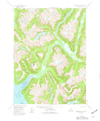
1955 Map of Ketchikan D-3
USGS Topo · Published 1960About this map
Chickamin River and its glacial-fed tributaries dominate this mid-century topographic study of the Tongass National Forest. The landscape is defined by deep fjords and steep drainage basins, where water moves from high alpine lakes like Leduc Lake and Heart Lake down to the Behm Canal. Human presence is sparse, represented by isolated outposts such as Wolf Cabin and another unnamed Cabin situated near the river's edge. The complex coastline features a prominent Tidal Flat near the mouth of the river, flanked by Fish Pt and Trap Pt. These coastal labels, along with the Channel Islands, reflect a maritime-dependent geography where transportation was limited to the water and rugged foot trails. The map provides a detailed view of the drainage patterns of Humpy Creek, Choco Creek, and King Creek as they carved through the wilderness before the era of modern development.
Find a feature on this map
19 named features on this map. Tap any name to fly to it.
Don’t see what you’re looking for? This feature index may not catch every label — zoom into the map to look around manually.
Map Details
Editions of this 1955 Ketchikan D-3 Map
3 editions found

Other maps of this area

1951 · Bradfield Canal
USGS Topo · 1:250,000

1952 · Ketchikan
USGS Topo · 1:250,000

1952 · Ketchikan C-4
USGS Topo · 1:63,360

1954 · Bradfield Canal
USGS Topo · 1:250,000

1955 · Ketchikan C-3
USGS Topo · 1:63,360

1955 · Ketchikan D-2
USGS Topo · 1:63,360

1955 · Bradfield canal A-4
USGS Topo · 1:63,360

1955 · Bradfield canal A-2
USGS Topo · 1:63,360

1955 · Ketchikan C-2
USGS Topo · 1:63,360

1955 · Ketchikan D-4
USGS Topo · 1:63,360