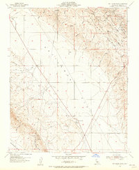
1953 Map of Kettleman Plain
USGS Topo · Published 1956About this map
The industrial and agricultural landscape of Kings County is defined here by the extensive oil production infrastructure across the Kettleman Hills. By the early 1950s, numerous Oil Wells and a complex network of pipelines crossed the terrain, centered around the North Dome and the prominent Skyline Road. In the valley below, Kettleman Plain transitions into the steep slopes of Reef Ridge to the south. Small outposts such as Reef Station and El Mirador mark the intersections of the era's desert roads, while seasonal drainages like Arroyo Delgado and Arroyo Estrada carve through the sedimentary ridges. The map reveals the mid-century petroleum economy, documenting the placement of a Pumping Station and a Landing Strip alongside named landmarks like Bullwheel Ridge and Cerro Ultimo.
Find a feature on this map
43 named features on this map. Tap any name to fly to it.
Don’t see what you’re looking for? This feature index may not catch every label — zoom into the map to look around manually.
Map Details
Editions of this 1953 Kettleman Plain Map
4 editions found
Other maps of this area

1912 · Coalinga
USGS Topo · 1:125,000

1914 · Lost Hills
USGS Topo · 1:125,000

1914 · Cholame
USGS Topo · 1:125,000

1915 · Cholame
USGS Topo · 1:125,000

1917 · Cholame
USGS Topo · 1:125,000

1930 · Discovery Well
USGS Topo · 1:31,680

1930 · Avenal Gap
USGS Topo · 1:31,680

1930 · Canoas Creek
USGS Topo · 1:31,680

1930 · Kettleman Plain
USGS Topo · 1:31,680

1930 · Middle Dome
USGS Topo · 1:31,680