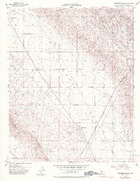
1953 Map of Kettleman Plain
USGS Topo · Published 1983About this map
Industrial infrastructure meets the arid ridges of the Kettleman Hills in this mid-century survey of the California oil fields. The landscape is defined by the extraction economy of the 1950s, dotted with oil wells, pumping stations, and oil tanks that follow the geology of the hills. Named outposts such as El Paso, El Campo, and El Dambo are scattered along the rising terrain, while Reef Station serves as a focal point in the lower Kettleman Plain. To the west, the topography shifts toward the Kreyenhagen Hills and Reef Ridge, where seasonal drainage from Arroyo Mellado and Big Tar Creek carves through the dry valleys. The straight lines of Tehama Avenue and Utica Avenue provide a stark geometric contrast to the winding tracks of Skyline Road and the natural contours of Drillers Hill.
Find a feature on this map
39 named features on this map. Tap any name to fly to it.
Don’t see what you’re looking for? This feature index may not catch every label — zoom into the map to look around manually.
Map Details
Editions of this 1953 Kettleman Plain Map
4 editions found
Other maps of this area

1912 · Coalinga
USGS Topo · 1:125,000

1914 · Lost Hills
USGS Topo · 1:125,000

1914 · Cholame
USGS Topo · 1:125,000

1915 · Cholame
USGS Topo · 1:125,000

1917 · Cholame
USGS Topo · 1:125,000

1930 · Discovery Well
USGS Topo · 1:31,680

1930 · Avenal Gap
USGS Topo · 1:31,680

1930 · Canoas Creek
USGS Topo · 1:31,680

1930 · Kettleman Plain
USGS Topo · 1:31,680

1930 · Middle Dome
USGS Topo · 1:31,680