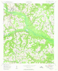
1950 Map of Keysville
USGS Topo · Published 1950About this map
Keysville and the agricultural lands along the Burke and Jefferson County line are detailed in this 1950 survey, based on aerial photography from 1947. The landscape is defined by the broad wetlands of Brier Creek and its many tributaries, including Brushy Creek and Reedy Creek. This era reveals a densely populated rural landscape centered on community institutions such as Boggs Academy and the combined St Clair Church and School. The prevalence of named ponds and mills, such as Meeks Mill Pond, points to the importance of water management in this mid-century farming economy. For genealogists and local historians, the map is a primary source for locating specific family-named landmarks like Dyes Crossroads and numerous country churches, including Clarks Chapel Church and Hopeful Church, which served as the social anchors of the Georgia countryside before the expansion of modern highways.
Find a feature on this map
44 named features on this map. Tap any name to fly to it.
Don’t see what you’re looking for? This feature index may not catch every label — zoom into the map to look around manually.
Map Details
Editions of this 1950 Keysville Map
2 editions found
Other maps of this area

1919 · Gough
USGS Topo · 1:62,500

1920 · Stapleton
USGS Topo · 1:62,500

1922 · Harlem
USGS Topo · 1:62,500

1922 · Hephzibah
USGS Topo · 1:62,500

1948 · Hephzibah
USGS Topo · 1:62,500

1948 · Harlem
USGS Topo · 1:62,500

1948 · Stapleton
USGS Topo · 1:62,500

1948 · Gough
USGS Topo · 1:62,500

1948 · Blythe
USGS Topo · 1:24,000
1950 · Hephzibah
USGS Topo · 1:24,000