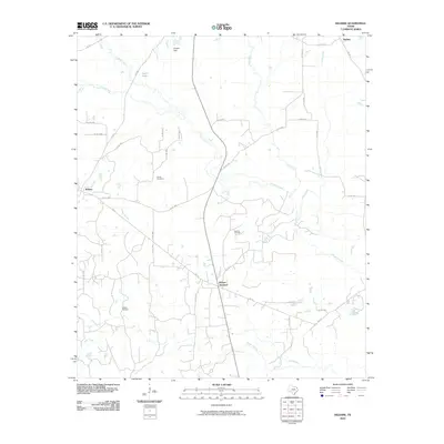
2010 Map of Kildare
USGS Topo · Published 2010About this map
Kildare and the nearby Kildare Junction serve as the primary nodes of settlement in this 2010 depiction of the East Texas landscape. The region is defined by a dense network of timbered creek bottoms and small water bodies, including Jim Bayou and Frazier Creek, which weave through the terrain. The presence of the Haynes Oil Field and Kildare Oil Field points to the continued significance of the petroleum industry in Cass County. For those tracing family ties to the area, Ferrell Cemetery is clearly marked north of the main Kildare settlement. The map also reveals the rural infrastructure of northern Cass County, with numerous farm-to-market roads like FM 125 and FM 248 connecting isolated homesteads and small communities such as Huffins in the northeast corner near Grogan Dam.
Find a feature on this map
44 named features on this map. Tap any name to fly to it.
Don’t see what you’re looking for? This feature index may not catch every label — zoom into the map to look around manually.
Map Details
Editions of this 2010 Kildare Map
This is the sole edition of this map. No revisions or reprints were ever made.
Other maps of this area

1907 · Atlanta
USGS Topo · 1:62,500

1910 · Linden
USGS Topo · 1:62,500

1910 · Atlanta
USGS Topo · 1:62,500

1944 · Kildare
USGS Topo · 1:62,500

1948 · Kildare
USGS Topo · 1:62,500

1953 · Texarkana
USGS Topo · 1:250,000

1956 · Texarkana
USGS Topo · 1:250,000

1956 · Tyler
USGS Topo · 1:250,000
1962 · McLeod
USGS Topo · 1:24,000

1962 · Lanier
USGS Topo · 1:24,000