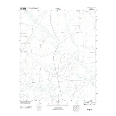
2013 Map of Kildare
USGS Topo · Published 2013About this map
Kildare and the nearby Kildare Junction serve as central points in this portion of Cass County, where the landscape is defined by a dense network of country roads and significant petroleum activity. The presence of the Haynes Oil Field and the Kildare Oil Field indicates the enduring industrial character of the region. Waterways such as Jim Bayou, Frazier Creek, and Corey Branch drain the terrain, creating a complex hydrographic pattern that includes Spear Lake and numerous unnamed smaller ponds. Local history and genealogy are anchored by the Ferrell Cemetery, situated among several connecting routes like Co RD-1891. In the northern section, the small community of Huffins sits near Cole Creek, while the southern reaches are marked by the winding path of Timber Branch. The map illustrates a contemporary rural Texas environment where traditional land divisions meet the infrastructure of modern energy extraction.
Find a feature on this map
54 named features on this map. Tap any name to fly to it.
Don’t see what you’re looking for? This feature index may not catch every label — zoom into the map to look around manually.
Map Details
Editions of this 2013 Kildare Map
This is the sole edition of this map. No revisions or reprints were ever made.
Other maps of this area

1907 · Atlanta
USGS Topo · 1:62,500

1910 · Linden
USGS Topo · 1:62,500

1910 · Atlanta
USGS Topo · 1:62,500

1944 · Kildare
USGS Topo · 1:62,500

1948 · Kildare
USGS Topo · 1:62,500

1953 · Texarkana
USGS Topo · 1:250,000

1956 · Texarkana
USGS Topo · 1:250,000

1956 · Tyler
USGS Topo · 1:250,000
1962 · McLeod
USGS Topo · 1:24,000

1962 · Lanier
USGS Topo · 1:24,000