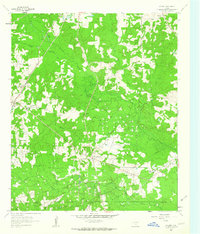
1962 Map of Kildare
USGS Topo · Published 1963About this map
The Kildare Oil Field and surrounding energy landscapes dominate this corner of Cass County, where the petroleum industry is etched into the terrain through a dense network of well sites and pipelines. The Texas and Pacific railroad serves as the primary corridor, connecting the small community of Kildare to Kildare Junction and the northern settlement of Huffines. This early 1960s landscape shows a community built around resource extraction and rural life, evidenced by the cluster of local institutions such as St John Ch, New Zion Ch, and the Linden-Kildare Jr High Sch.
Find a feature on this map
26 named features on this map. Tap any name to fly to it.
Don’t see what you’re looking for? This feature index may not catch every label — zoom into the map to look around manually.
Map Details
Editions of this 1962 Kildare Map
2 editions found
Other maps of this area

1907 · Atlanta
USGS Topo · 1:62,500

1910 · Linden
USGS Topo · 1:62,500

1910 · Atlanta
USGS Topo · 1:62,500

1944 · Kildare
USGS Topo · 1:62,500

1948 · Kildare
USGS Topo · 1:62,500

1953 · Texarkana
USGS Topo · 1:250,000

1956 · Texarkana
USGS Topo · 1:250,000

1956 · Tyler
USGS Topo · 1:250,000
1962 · McLeod
USGS Topo · 1:24,000

1962 · Lanier
USGS Topo · 1:24,000