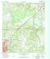
1971 Map of Kilgore NE
USGS Topo · Published 1985About this map
The oil-rich landscape of East Texas unfolds across this 1971 survey, showing the northern reach of Kilgore and the southern edge of Longview. The industrial character of the region is evident in the numerous oil wells and pumping stations scattered among the piney woods and bottomlands of the Sabine River. Smaller, long-standing communities such as Danville, Fredonia, and Peatown punctuate the rural areas, often centered around local landmarks like the Peatown Ch and Utzman Cem.
Find a feature on this map
64 named features on this map. Tap any name to fly to it.
Don’t see what you’re looking for? This feature index may not catch every label — zoom into the map to look around manually.
Map Details
Editions of this 1971 Kilgore NE Map
2 editions found
Other maps of this area

1936 · Kilgore
USGS Topo · 1:48,000

1940 · Kilgore
USGS Topo · 1:62,500

1956 · Tyler
USGS Topo · 1:250,000

1958 · Tatum
USGS Topo · 1:62,500

1960 · White Oak
USGS Topo · 1:24,000

1960 · Gladewater
USGS Topo · 1:24,000

1962 · Longview Heights
USGS Topo · 1:24,000

1971 · Kilgore NE
USGS Topo · 1:24,000
1971 · Kilgore SW
USGS Topo · 1:24,000
1971 · Kilgore NW
USGS Topo · 1:24,000