
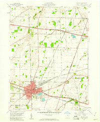
1959 Map of Kimball
USGS Topo · Published 1960About this map
The Plum Brook Ordnance Works dominates the northern landscape of this 1959 survey, reflecting the significant military and industrial presence in Erie County following the war years. To the south, the terrain transitions into a dense network of transport and small settlements, where the Ohio Turnpike cuts a modern path across older agricultural townships. The region is anchored by established communities like Bloomingville, Kimball, and North Monroeville, each connected by a complex system of rail lines including the Baltimore and Ohio and the New York Chicago and St Louis.
Find a feature on this map
36 named features on this map. Tap any name to fly to it.
Don’t see what you’re looking for? This feature index may not catch every label — zoom into the map to look around manually.
Map Details
Editions of this 1959 Kimball Map
This is the sole edition of this map. No revisions or reprints were ever made.
Other maps of this area

1901 · Bellevue
USGS Topo · 1:62,500

1903 · Bellevue
USGS Topo · 1:62,500

1904 · Sandusky
USGS Topo · 1:62,500

1915 · Norwalk
USGS Topo · 1:62,500

1915 · Siam
USGS Topo · 1:62,500

1944 · Norwalk
USGS Topo · 1:62,500

1956 · Toledo
USGS Topo · 1:250,000

1959 · Milan
USGS Topo · 1:24,000

1959 · Sandusky
USGS Topo · 1:24,000
1959 · Bellevue
USGS Topo · 1:24,000