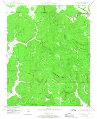
1948 Map of King Cove
USGS Topo · Published 1967About this map
Putman Mountain and Backbone Mountain dominate this corner of the Alabama-Tennessee border, where the Tennessee Valley Authority and U.S. Geological Survey documented a landscape defined by deep coves and karst features. The 1948 field examination recorded the remote settlement of Francisco in the northeast corner, situated near the headwaters of Pigeon Creek. The area is characterized by significant geological depressions such as Hambrick Sinks and Cunningham Sinks, illustrating the unique subterranean drainage of the region.
Find a feature on this map
73 named features on this map. Tap any name to fly to it.
Don’t see what you’re looking for? This feature index may not catch every label — zoom into the map to look around manually.
Map Details
Editions of this 1948 King Cove Map
3 editions found
Other maps of this area

1888 · Scottsboro
USGS Topo · 1:125,000

1892 · Scottsboro
USGS Topo · 1:125,000

1928 · Decherd
USGS Topo · 1:62,500

1936 · King Cove
USGS Topo · 1:24,000

1936 · Flintville
USGS Topo · 1:24,000

1936 · Hollytree
USGS Topo · 1:24,000

1936 · Beans Creek
USGS Topo · 1:24,000

1936 · Princeton
USGS Topo · 1:24,000

1936 · Huntland
USGS Topo · 1:24,000

1936 · Maysville
USGS Topo · 1:24,000