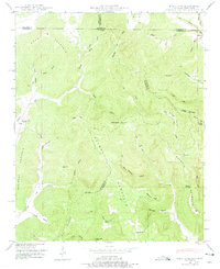
1948 Map of King Cove
USGS Topo · Published 1975About this map
Putman Mountain and Maxwell Mountain dominate this late 1940s landscape on the Alabama-Tennessee border, where the convergence of Madison, Jackson, and Franklin counties creates a complex terrain of isolated coves and high tops. The small settlement of Francisco sits in the northeast corner near Beech Grove Cemetery, marking one of the few concentrated areas of habitation. Elsewhere, the map reveals a scattered network of family landmarks and rural institutions, such as Mountain Fork Church and Hambrick School, which served the residents of the surrounding hollows.
Find a feature on this map
61 named features on this map. Tap any name to fly to it.
Don’t see what you’re looking for? This feature index may not catch every label — zoom into the map to look around manually.
Map Details
Editions of this 1948 King Cove Map
3 editions found
Other maps of this area

1888 · Scottsboro
USGS Topo · 1:125,000

1892 · Scottsboro
USGS Topo · 1:125,000

1928 · Decherd
USGS Topo · 1:62,500

1936 · King Cove
USGS Topo · 1:24,000

1936 · Flintville
USGS Topo · 1:24,000

1936 · Hollytree
USGS Topo · 1:24,000

1936 · Beans Creek
USGS Topo · 1:24,000

1936 · Princeton
USGS Topo · 1:24,000

1936 · Huntland
USGS Topo · 1:24,000

1936 · Maysville
USGS Topo · 1:24,000