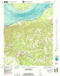
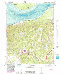
1968 Map of King George
USGS Topo · Published 1985About this map
Potomac River shorelines and the interior uplands of King George County define this mid-century landscape, capturing the area before modern residential expansion. The survey highlights a rural network of small communities and family-named junctions such as Arnolds Corner, Whites Corner, and Purkins Corner, which served as local anchors for the surrounding farming district. Religious and educational life is well-documented through numerous sites like St Stephens Ch, Peoples Union Ch, and both King George High Sch and Bunche High Sch. Along the river, specialized land use is evident at the Naval Research Lab Maryland Point Antenna Range near Merrick Boys Camp, while the tidal flats of Mudds Marsh and the reach of Upper Machodoc Creek show the importance of the waterfront. The map also records early leisure and housing patterns at Fairview Beach and Somerset Beach.
Find a feature on this map
44 named features on this map. Tap any name to fly to it.
Don’t see what you’re looking for? This feature index may not catch every label — zoom into the map to look around manually.
Map Details
Editions of this 1968 King George Map
5 editions found
Other maps of this area

1889 · Fredericksburg
USGS Topo · 1:125,000

1892 · Fredericksburg
USGS Topo · 1:125,000

1894 · Fredericksburg
USGS Topo · 1:125,000

1913 · Nanjemoy
USGS Topo · 1:62,500

1926 · Stafford
USGS Topo · 1:62,500

1931 · Stafford
USGS Topo · 1:62,500

1942 · Rollins Fork
USGS Topo · 1:31,680

1942 · Port Royal
USGS Topo · 1:31,680

1942 · Rappahannock Academy
USGS Topo · 1:31,680
1944 · Widewater
USGS Topo · 1:31,680