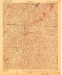
1908 Map of Kings Mountain
USGS Topo · Published 1920About this map
Kings Mountain Battleground stands as the historical centerpiece of this 1906 survey, marking the Revolutionary War site along the border of North and South Carolina. The terrain is defined by the sharp rise of the Kings Mountain range, including The Pinnacle, Crowders Mtn, and several notable gaps like Dixon Gap. This era reveals a landscape deeply connected by a network of rural institutions, from the Lincoln Academy near the northern border to numerous country churches such as Smyrna Church and Ramah Church. Local travel and transport in the early twentieth century relied on the Southern RR and river crossings like Bordens Ferry on the Broad River. The map also captures early mineral and social interest in the region's waters at Piedmont Springs and Allhealing Spring, offering a view of the area before modern development altered the Piedmont landscape.
Find a feature on this map
66 named features on this map. Tap any name to fly to it.
Don’t see what you’re looking for? This feature index may not catch every label — zoom into the map to look around manually.
Map Details
Editions of this 1908 Kings Mountain Map
6 editions found

Other maps of this area

1906 · Kings Mountain
USGS Topo · 1:62,500

1907 · Sharon
USGS Topo · 1:62,500

1908 · Kings Mountain
USGS Topo · 1:62,500

1909 · Gaffney
USGS Topo · 1:62,500

1909 · Lincolnton
USGS Topo · 1:62,500

1911 · Lincolnton
USGS Topo · 1:62,500

1914 · Gastonia
USGS Topo · 1:48,000

1916 · Gastonia
USGS Topo · 1:62,500

1941 · Spartanburg
USGS Topo · 1:250,000

1947 · Clover
USGS Topo · 1:62,500