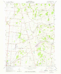
1961 Map of Kingscreek
USGS Topo · Published 1974About this map
Ohio Caverns and the surrounding agricultural landscape of Champaign County define this topographic study, recorded just before mid-century and updated with 1973 revisions. The area is characterized by a dense network of family-named roads and rural infrastructure, including Township High Sch and several country churches like Mt Tabor Ch and Union Chapel. Small settlements such as Kingscreek and Kennard serve as local hubs along the Erie-Lackawanna and Penn Central railroads, which once facilitated the movement of goods and people across the Miami District.
Find a feature on this map
62 named features on this map. Tap any name to fly to it.
Don’t see what you’re looking for? This feature index may not catch every label — zoom into the map to look around manually.
Map Details
Editions of this 1961 Kingscreek Map
Other maps of this area

1913 · Bellefontaine
USGS Topo · 1:48,000

1913 · East Liberty
USGS Topo · 1:62,500

1914 · St. Paris
USGS Topo · 1:62,500

1914 · Mechanicsburg
USGS Topo · 1:62,500

1915 · Bellefontaine
USGS Topo · 1:62,500

1915 · East Liberty
USGS Topo · 1:62,500

1916 · Mechanicsburg
USGS Topo · 1:62,500

1916 · St. Paris
USGS Topo · 1:62,500

1944 · East Liberty
USGS Topo · 1:62,500

1944 · Mechanicsburg
USGS Topo · 1:62,500