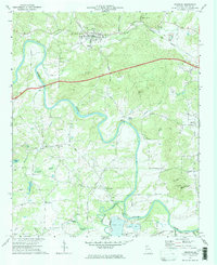
1972 Map of Kingston
USGS Topo · Published 1974About this map
Kingston serves as the central hub of this Bartow County landscape, where the confluence of rail history and the Etowah River shapes the local geography. The map documents an intricate network of rural spiritual life, with congregations established at Shiloh Ch, Queens Chapel, and Macedonia Ch dotting the countryside. Evidence of the region’s older transport infrastructure is visible in the Louisville and Nashville RR Grade and the Louisville Old RR Grade, tracing former paths of commerce through the river valley. The terrain is marked by significant natural landmarks such as Saltpeter Cave and Hodge Mtn, while the winding Euharlee Creek is crossed by a notable Covered Bridge and Milams Bridge. This 1972 survey records the area just as modern utilities like the Filtration Plant and various pipelines began to integrate with the traditional agricultural and river-based settlement patterns.
Find a feature on this map
46 named features on this map. Tap any name to fly to it.
Don’t see what you’re looking for? This feature index may not catch every label — zoom into the map to look around manually.
Map Details
Editions of this 1972 Kingston Map
2 editions found
Other maps of this area

1886 · Rome
USGS Topo · 1:125,000

1890 · Cartersville
USGS Topo · 1:125,000

1891 · Cartersville
USGS Topo · 1:125,000

1896 · Cartersville
USGS Topo · 1:125,000

1898 · Rome
USGS Topo · 1:125,000

1899 · Rome
USGS Topo · 1:125,000

1904 · Rome
USGS Topo · 1:125,000

1906 · Stilesboro
USGS Topo · 1:62,500

1908 · Stilesboro
USGS Topo · 1:62,500

1941 · Adairsville
USGS Topo · 1:62,500