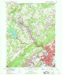
1946 Map of Kingston
USGS Topo · Published 1969About this map
The Susquehanna River defines the southeastern border of this mid-century landscape, where the dense boroughs of Kingston, Forty Fort, and Edwardsville contrast with the expanding residential suburbs to the northwest. The terrain climbs from the river flats toward Chestnut Ridge, passing through the developing communities of Shavertown and Trucksville. Educational and religious institutions are prominent features, from the campus of Misericordia College near Dallas to the historic Wyoming Seminary in Kingston.
Find a feature on this map
82 named features on this map. Tap any name to fly to it.
Don’t see what you’re looking for? This feature index may not catch every label — zoom into the map to look around manually.
Map Details
Editions of this 1946 Kingston Map
5 editions found
Other maps of this area

1891 · Wilkesbarre
USGS Topo · 1:62,500

1891 · Harveys Lake
USGS Topo · 1:62,500

1893 · Harvey Lake
USGS Topo · 1:62,500

1893 · Pittston
USGS Topo · 1:62,500

1894 · Shickshinny
USGS Topo · 1:62,500

1894 · Wilkesbarre
USGS Topo · 1:62,500

1943 · Scranton
USGS Topo · 1:125,000

1946 · Nanticoke
USGS Topo · 1:31,680

1946 · Kingston
USGS Topo · 1:24,000

1946 · Harveys Lake
USGS Topo · 1:24,000