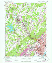
1946 Map of Kingston
USGS Topo · Published 1977About this map
Kingston and its neighboring boroughs of Forty Fort, Swoyersville, and Edwardsville anchor this detailed survey of the Wyoming Valley. Along the Susquehanna River, the landscape is densely developed, featuring prominent institutions like the Wyoming Seminary and Nesbitt Memorial Hospital. The industrial character of the region is evident in the presence of a Strip Mine and Coal deposits near Larksville, while the Conrail lines trace the corridor of historical trade and transport.
Find a feature on this map
95 named features on this map. Tap any name to fly to it.
Don’t see what you’re looking for? This feature index may not catch every label — zoom into the map to look around manually.
Map Details
Editions of this 1946 Kingston Map
5 editions found
Other maps of this area

1891 · Wilkesbarre
USGS Topo · 1:62,500

1891 · Harveys Lake
USGS Topo · 1:62,500

1893 · Harvey Lake
USGS Topo · 1:62,500

1893 · Pittston
USGS Topo · 1:62,500

1894 · Shickshinny
USGS Topo · 1:62,500

1894 · Wilkesbarre
USGS Topo · 1:62,500

1943 · Scranton
USGS Topo · 1:125,000

1946 · Nanticoke
USGS Topo · 1:31,680

1946 · Kingston
USGS Topo · 1:24,000

1946 · Harveys Lake
USGS Topo · 1:24,000