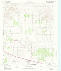
1967 Map of Kirkland North
USGS Topo · Published 1981About this map
Kirkland stands as a focal point in this portion of Childress County, situated along the Fort Worth and Denver railroad line. The settlement pattern here is closely tied to the transit corridor in the south and the meandering path of North Groesbeck Creek which cuts through the central landscape. The prevalence of individual wells across the terrain suggests a dispersed rural population reliant on localized water sources for ranching or agriculture during the late 1960s. Near the town site, the Kirkland Cem serves as a primary point of interest for genealogists tracing local families. Industrial and infrastructure markers, including a Pipeline, various Gravel Pits, and a remote Landing Strip, reflect the region's mid-century development. A small Community Center further north indicates a secondary node of local gathering and social organization in this rural Texas expanse.
Find a feature on this map
9 named features on this map. Tap any name to fly to it.
Don’t see what you’re looking for? This feature index may not catch every label — zoom into the map to look around manually.
Map Details
Editions of this 1967 Kirkland North Map
2 editions found
Other maps of this area

1954 · Plainview
USGS Topo · 1:250,000

1955 · Lawton
USGS Topo · 1:250,000

1958 · Plainview
USGS Topo · 1:250,000

1960 · Goodlett
USGS Topo · 1:62,500

1960 · Loco
USGS Topo · 1:62,500

1961 · Hollis
USGS Topo · 1:62,500

1967 · Buckle L Ranch
USGS Topo · 1:24,000

1967 · Kirkland South
USGS Topo · 1:24,000

1967 · Kirkland North
USGS Topo · 1:24,000

1967 · Childress
USGS Topo · 1:24,000