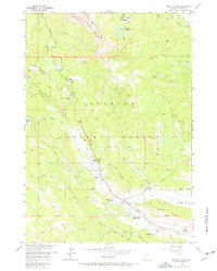
1956 Map of Kisinger Lakes
USGS Topo · Published 1972About this map
Pinnacle Buttes dominate the skyline of this high-altitude landscape within the Shoshone National Forest, captured during a 1956 field survey. The area serves as a rugged intersection of wilderness management and early 20th-century history, marked by the Tie Hack Historical Monument near the headwaters of the Wind River. This reach of the river valley is dotted with historic working properties including Triangle C Ranch, Griffith Ranch, and Lava Creek Ranch, suggesting a legacy of ranching and outfitting that persisted into the mid-century. Mapping includes critical backcountry infrastructure such as the Sheridan Creek Guard Station and a First Aid Station, alongside recreation sites like Pinnacle Campground. Numerous alpine water bodies, including Kisinger Lakes and Mud Lake, feed the network of creeks that carve through the surrounding Elk Ridge.
Find a feature on this map
29 named features on this map. Tap any name to fly to it.
Don’t see what you’re looking for? This feature index may not catch every label — zoom into the map to look around manually.
Map Details
Editions of this 1956 Kisinger Lakes Map
4 editions found
Other maps of this area

1902 · Mt Leidy
USGS Topo · 1:125,000

1905 · Younts Peak
USGS Topo · 1:125,000

1907 · Younts Peak
USGS Topo · 1:125,000

1955 · Driggs
USGS Topo · 1:250,000

1955 · Thermopolis
USGS Topo · 1:250,000

1956 · Esmond Park
USGS Topo · 1:24,000

1956 · Shoshone Pass
USGS Topo · 1:24,000

1956 · Warm Spring Mountain
USGS Topo · 1:24,000

1956 · Fish Lake
USGS Topo · 1:24,000

1956 · Kisinger Lakes
USGS Topo · 1:24,000