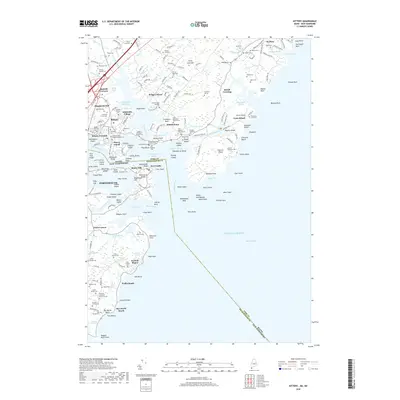
2018 Map of Kittery
USGS Topo · Published 2018About this map
Kittery and its adjacent coastal reaches are defined by a complex network of tidal inlets and islands where the Piscataqua River meets the Atlantic Ocean. This maritime landscape is punctuated by numerous family lots and historic burial sites, including the Brackett Massacre Burial Ground and the United States Naval Shipyard Cem on Seavey Island. The survey documents a deep genealogical record through named properties such as the Captain Benjamin Fernald Lot and the Norton Mugridge Lot, alongside larger settlements like Admiralty Village and Kittery Foreside. Along the southern shoreline, New Castle Island and the grounds of Fort Point guard the entrance to the harbor. The interior landscape transitions into wooded tracts like Forty Acre Hill and significant wetlands such as Fairhill Swamp, while the rugged coast is marked by features like Seal Rocks and the shoreline of Foss Beach.
Find a feature on this map
209 named features on this map. Tap any name to fly to it.
Don’t see what you’re looking for? This feature index may not catch every label — zoom into the map to look around manually.
Map Details
Editions of this 2018 Kittery Map
This is the sole edition of this map. No revisions or reprints were ever made.
Other maps of this area

1888 · Newburyport
USGS Topo · 1:62,500

1890 · Newburyport
USGS Topo · 1:62,500

1893 · Dover
USGS Topo · 1:62,500

1893 · York
USGS Topo · 1:62,500

1894 · Newburyport
USGS Topo · 1:62,500

1916 · Dover
USGS Topo · 1:62,500

1918 · Dover
USGS Topo · 1:62,500

1920 · York
USGS Topo · 1:62,500

1932 · Newburyport
USGS Topo · 1:48,000

1934 · Exeter
USGS Topo · 1:62,500