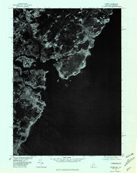
1977 Map of Kittery
USGS Topo · Published 1981About this map
The coastal village of Kittery Point and the neighboring residential pocket of Fairhill Manor stand at the edge of the Atlantic in this late-1970s aerial study. This orthophotoquad, produced by the Geological Survey in cooperation with the Soil Conservation Service, provides an unfiltered look at the Maine and New Hampshire coastline as it appeared during the spring of 1977. Unlike traditional line-drawn maps, this photo-based document reveals the raw density of development on Seavey Island and the intricate, rocky nature of the shoreline around the mouth of the harbor. Local historians can trace the exact footprint of piers, buildings, and suburban expansion during a period of steady growth for this maritime community.
Find a feature on this map
3 named features on this map. Tap any name to fly to it.
Don’t see what you’re looking for? This feature index may not catch every label — zoom into the map to look around manually.
Map Details
Editions of this 1977 Kittery Map
This is the sole edition of this map. No revisions or reprints were ever made.
Other maps of this area

1888 · Newburyport
USGS Topo · 1:62,500

1890 · Newburyport
USGS Topo · 1:62,500

1893 · Dover
USGS Topo · 1:62,500

1893 · York
USGS Topo · 1:62,500

1894 · Newburyport
USGS Topo · 1:62,500

1916 · Dover
USGS Topo · 1:62,500

1918 · Dover
USGS Topo · 1:62,500

1920 · York
USGS Topo · 1:62,500

1932 · Newburyport
USGS Topo · 1:48,000

1934 · Exeter
USGS Topo · 1:62,500