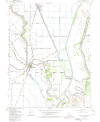
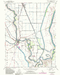
1952 Map of Knights Landing
USGS Topo · Published 1974About this map
Knights Landing serves as the focal point for this survey of the Sacramento Valley, where the Sacramento River makes several tight bends including Railroad Bend and Fourmile Bend. The landscape is defined by massive water management infrastructure, most notably the broad Sutter Bypass and the Knights Landing Ridge Cut, designed to control the volatile floodwaters of the Central Valley. Agriculture dominates the flats between the river and the bypass, supported by an intricate network of pumping stations and drainage canals like the Colusa Basin Drainage Canal. The presence of the Southern Pacific Railroad and the Sacramento Northern line through the town of Robbins highlights the importance of rail transport for moving the region's agricultural harvest. Scattered throughout the floodplain are local landmarks such as Knights School and several oxbow water bodies like Mary Lake and Horseshoe Lake.
Find a feature on this map
45 named features on this map. Tap any name to fly to it.
Don’t see what you’re looking for? This feature index may not catch every label — zoom into the map to look around manually.
Map Details
Editions of this 1952 Knights Landing Map
5 editions found
Other maps of this area

1907 · Dunnigan
USGS Topo · 1:62,500

1907 · Woodland
USGS Topo · 1:62,500

1907 · Davisville
USGS Topo · 1:62,500

1910 · Knights Landing
USGS Topo · 1:31,680

1910 · Vernon
USGS Topo · 1:31,680

1910 · Nicolaus
USGS Topo · 1:31,680

1910 · Marcuse
USGS Topo · 1:31,680

1915 · Yolo
USGS Topo · 1:31,680

1915 · Ronda
USGS Topo · 1:31,680
1915 · Kirkville
USGS Topo · 1:31,680