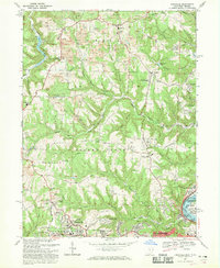
1968 Map of Knoxville
USGS Topo · Published 1970About this map
Island Creek and its many tributaries, including Shelley Run and Dungeon Hollow Run, carve through the landscape of Jefferson County during this late 1960s revision. The area shows a heavy industrial imprint from numerous Strip Mine operations scattered throughout Knox and Island Creek townships. In the south, the growing suburban footprint of Wintersville and Overlook Hills contrasts with the rural character of northern settlements like Knoxville and Taylortown. The transportation network is anchored by the Ohio River and the Penn Central railroad corridors on the eastern edge near Toronto. Local genealogy is well-supported by several listed burial sites, including Shelley Cem, the hilltop Mt Tabor Cem, and the expansive Fort Steuben Burial Estates. Educational and community life is centered at the Jefferson Union High Sch and several country churches like Center Chapel and Brays Chapel.
Find a feature on this map
60 named features on this map. Tap any name to fly to it.
Don’t see what you’re looking for? This feature index may not catch every label — zoom into the map to look around manually.
Map Details
Editions of this 1968 Knoxville Map
Other maps of this area

1901 · Cadiz
USGS Topo · 1:62,500

1903 · Cadiz
USGS Topo · 1:62,500

1904 · Wellsville
USGS Topo · 1:62,500

1904 · Steubenville
USGS Topo · 1:62,500

1905 · Salineville
USGS Topo · 1:62,500

1935 · Steubenville
USGS Topo · 1:62,500

1937 · Wellsville
USGS Topo · 1:62,500

1942 · Steubenville
USGS Topo · 1:62,500

1944 · Wellsville
USGS Topo · 1:62,500

1951 · Canton
USGS Topo · 1:250,000