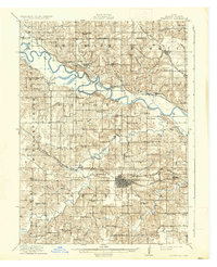
1912 Map of Knoxville
USGS Topo · Published 1937About this map
The Des Moines River winds through the heart of Marion County, anchoring a landscape defined by its early 20th-century rail infrastructure and a dense network of rural one-room schools. Knoxville serves as the central hub, where the Chicago Burlington and Quincy RR and the Chicago Rock Island and Pacific RR converge to support the regional economy. Beyond the town limits, the terrain is partitioned into townships like Red Rock and Summit, populated by small riverside settlements such as Cordova and Dunreath. The map reveals a highly localized education system, with schools like Coal Ridge School, Stringtown School, and Buckeye School serving family farms along the tributaries of Whitebreast Creek and English Creek. This era represents a time before modern consolidation, where local life revolved around these country schoolhouses and the Wabash RR lines that tied the valley to broader markets.
Find a feature on this map
75 named features on this map. Tap any name to fly to it.
Don’t see what you’re looking for? This feature index may not catch every label — zoom into the map to look around manually.
Map Details
Editions of this 1912 Knoxville Map
2 editions found
Other maps of this area

1909 · Knoxville
USGS Topo · 1:62,500

1910 · Milo
USGS Topo · 1:62,500

1910 · Pella
USGS Topo · 1:62,500

1912 · Knoxville
USGS Topo · 1:62,500

1912 · Pella
USGS Topo · 1:62,500

1918 · Chariton
USGS Topo · 1:62,500

1924 · Melcher
USGS Topo · 1:62,500

1929 · Albia
USGS Topo · 1:62,500

1930 · Mitchellville
USGS Topo · 1:62,500

1954 · Des Moines
USGS Topo · 1:250,000