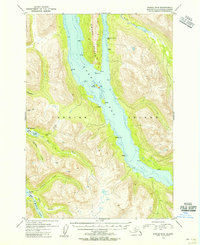
1954 Map of Kodiak B-6
USGS Topo · Published 1955About this map
Uyak Bay dominates this mid-century Alaskan landscape, slicing deep into the western side of Kodiak Island. The map documents a period of transition in the territory's maritime and mining history, notably marking a Mine (Aban'd) and a Camp (Aban'd) on the northern reach of Amook Island. Small signs of former activity are scattered along the shoreline, including a Cem and Ruins near the southern waters. Inland, the topography is defined by the drainage systems of North Fork Salmon Creek and the East Fork Salmon Creek, which feed toward Karluk Lake. This survey illustrates the isolation and seasonal industry of the region before statehood, where survival and commerce were tied to the deep-water access of the bay and the freshwater resources of O'Malley Lake and Thumb Lake.
Find a feature on this map
24 named features on this map. Tap any name to fly to it.
Don’t see what you’re looking for? This feature index may not catch every label — zoom into the map to look around manually.
Map Details
Editions of this 1954 Kodiak B-6 Map
This is the sole edition of this map. No revisions or reprints were ever made.
Other maps of this area

1951 · Karluk
USGS Topo · 1:250,000

1952 · Kodiak
USGS Topo · 1:250,000

1952 · Karluk
USGS Topo · 1:250,000

1952 · Kodiak B-6
USGS Topo · 1:63,360

1952 · Karluk B-1
USGS Topo · 1:63,360

1952 · Kodiak C-5
USGS Topo · 1:63,360

1952 · Kodiak B-5
USGS Topo · 1:63,360

1952 · Karluk C-1
USGS Topo · 1:63,360

1952 · Kodiak C-6
USGS Topo · 1:63,360

1952 · Karluk A-1
USGS Topo · 1:63,360