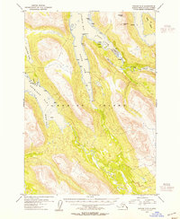
1954 Map of Kodiak C-5
USGS Topo · Published 1955About this map
Kodiak Island is defined by its deep glacial fjords and steep mountain ridges in this mid-century survey, with the entire land area falling within the Kodiak National Wildlife Refuge. Commercial activity centers on the water, evidenced by a Saltery and several Cabins positioned along the East Arm of Uganik Bay. These small settlements and isolated structures are tucked against the slopes of Helmet Mtn and Dog Ear Mtn, revealing a landscape where coastal access was essential for early industry and survival.
Find a feature on this map
36 named features on this map. Tap any name to fly to it.
Don’t see what you’re looking for? This feature index may not catch every label — zoom into the map to look around manually.
Map Details
Editions of this 1954 Kodiak C-5 Map
This is the sole edition of this map. No revisions or reprints were ever made.
Other maps of this area

1951 · Kodiak D-6
USGS Topo · 1:63,360

1952 · Kodiak
USGS Topo · 1:250,000

1952 · Kodiak B-6
USGS Topo · 1:63,360

1952 · Kodiak C-4
USGS Topo · 1:63,360

1952 · Kodiak C-5
USGS Topo · 1:63,360

1952 · Kodiak D-5
USGS Topo · 1:63,360

1952 · Kodiak B-5
USGS Topo · 1:63,360

1952 · Kodiak C-6
USGS Topo · 1:63,360

1952 · Kodiak D-4
USGS Topo · 1:63,360

1952 · Kodiak B-4
USGS Topo · 1:63,360