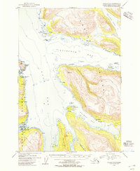
1954 Map of Kodiak C-6
USGS Topo · Published 1955About this map
Larsen Bay serves as a primary coastal focal point on this mid-century survey of Kodiak Island. The map documents the vital maritime infrastructure of the era, showing a Cannery on the shores of Zachar Bay and technical installations like Radio Towers, a Tank, and an Aqueduct supporting the local population. Coastal activity is evident through numerous Cabins scattered along the shoreline and the protection afforded by Uyak Anchorage near Harvester Island. Deeply indented fjords including Spiridon Bay and Uyak Bay define the landscape, where landmarks such as Chief Pt and Hook Pt guided mariners. This period of record-keeping within the Kodiak National Wildlife Refuge captures a specific era of Alaskan fishing and communication history, evidenced by the presence of a Cem and isolated outposts on Amook Island.
Find a feature on this map
35 named features on this map. Tap any name to fly to it.
Don’t see what you’re looking for? This feature index may not catch every label — zoom into the map to look around manually.
Map Details
Editions of this 1954 Kodiak C-6 Map
This is the sole edition of this map. No revisions or reprints were ever made.
Other maps of this area

1951 · Karluk
USGS Topo · 1:250,000

1951 · Kodiak D-6
USGS Topo · 1:63,360

1952 · Kodiak
USGS Topo · 1:250,000

1952 · Karluk
USGS Topo · 1:250,000

1952 · Kodiak B-6
USGS Topo · 1:63,360

1952 · Karluk B-1
USGS Topo · 1:63,360

1952 · Kodiak C-5
USGS Topo · 1:63,360

1952 · Kodiak D-5
USGS Topo · 1:63,360

1952 · Kodiak B-5
USGS Topo · 1:63,360

1952 · Karluk C-1
USGS Topo · 1:63,360