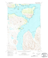
1947 Map of Kodiak D-3
USGS Topo · Published 1979About this map
Port Lions sits on the western shore of Settler Cove, serving as a focal point for maritime activity in this coastal region of Kodiak Island. The map illustrates a developed waterfront including the Wakefield Wharf, a Seaplane Landing, and a Power Sta, reflecting the infrastructure required for remote Alaskan settlements. The landscape is defined by the narrow maritime corridors of Kupreanof Strait and Whale Passage, which separate large landmasses such as Whale Island and Raspberry Island. Significant portions of the territory are managed under federal protections, including the Afognak National Forest and the Kodiak National Wildlife Refuge. From the peaks of Sharatin Bay to the inlets of Kizhuyak Bay, the map details a world where the sea is the primary highway, punctuated by distinctive landmarks like Ilkognak Rock and Talnik Point.
Find a feature on this map
64 named features on this map. Tap any name to fly to it.
Don’t see what you’re looking for? This feature index may not catch every label — zoom into the map to look around manually.
Map Details
Editions of this 1947 Kodiak D-3 Map
3 editions found
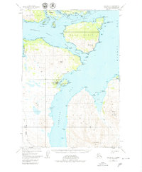
Other maps of this area

1947 · Kodiak D-3
USGS Topo · 1:63,360

1949 · Kodiak C-2
USGS Topo · 1:63,360

1949 · Kodiak D-2
USGS Topo · 1:63,360

1949 · Kodiak D-3
USGS Topo · 1:63,360

1950 · Kodiak D-3
USGS Topo · 1:63,360

1951 · Kodiak D-2
USGS Topo · 1:63,360

1952 · Kodiak
USGS Topo · 1:250,000

1952 · Afognak
USGS Topo · 1:250,000

1952 · Kodiak C-3
USGS Topo · 1:63,360

1952 · Afognak A-4
USGS Topo · 1:63,360