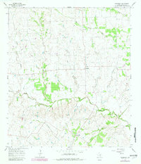
1965 Map of Komensky
USGS Topo · Published 1982About this map
The Lavaca River and its numerous tributaries, including the West Prong Lavaca River and Smothers Creek, dominate this rural Texas landscape. Small, localized settlements such as Komensky, Novohrad, and Witting serve as the primary nodes of human activity, connected by a network of farm roads and drainage basins. The area’s genealogical record is anchored by sites like Baursville Cem near Baursville and the Breslau Cem in the southeastern corner. This mid-1960s survey, updated with 1970s revisions, reveals a landscape primarily defined by agricultural boundaries and ranching, evidenced by the many fence lines and cattle-traversed terrain between Liveoak Creek and Boggy Creek. The presence of several Gravel Pits suggests localized resource extraction supporting the community's road infrastructure during this era.
Find a feature on this map
17 named features on this map. Tap any name to fly to it.
Don’t see what you’re looking for? This feature index may not catch every label — zoom into the map to look around manually.
Map Details
Editions of this 1965 Komensky Map
2 editions found
Other maps of this area

1901 · Flatonia
USGS Topo · 1:125,000

1919 · Schulenburg
USGS Topo · 1:62,500

1953 · Seguin
USGS Topo · 1:250,000

1958 · Seguin
USGS Topo · 1:250,000

1962 · Hallettsville
USGS Topo · 1:24,000

1965 · Schulenburg
USGS Topo · 1:24,000

1965 · Wied
USGS Topo · 1:24,000

1965 · Komensky
USGS Topo · 1:24,000
1965 · Moravia
USGS Topo · 1:24,000

1965 · Flatonia
USGS Topo · 1:24,000