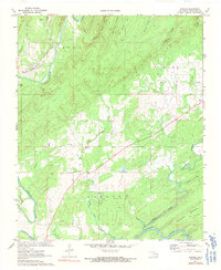
1972 Map of Kosoma
USGS Topo · Published 1991About this map
Kiamichi River bottomlands dominate this landscape in Pushmataha County, where the valley floor meets the rising timber of Lost Mtn. In the early 1970s, the community of Kosoma served as a key point along the St Louis San Francisco RR, which follows the river's path through the terrain. The map records a rural infrastructure defined by local spiritual and family centers, such as Little Cedar Ch and Old Cedar Ch, alongside the Finley Cem near the eastern boundary. Industrial activity is represented by a Gravel Pit near the riverbanks, suggesting the extraction of local resources. Water is the primary architect of the land here, with a complex network of tributaries including Caroline Creek and Cedar Mountain Creek feeding into the larger river system, supporting the agriculture and settlement patterns of this Oklahoma interior.
Find a feature on this map
30 named features on this map. Tap any name to fly to it.
Don’t see what you’re looking for? This feature index may not catch every label — zoom into the map to look around manually.
Map Details
Editions of this 1972 Kosoma Map
2 editions found
Other maps of this area

1901 · Antlers
USGS Topo · 1:125,000

1901 · Alikchi
USGS Topo · 1:125,000

1912 · Antlers
USGS Topo · 1:125,000

1925 · Antlers
USGS Topo · 1:125,000

1950 · Mcalester
USGS Topo · 1:250,000

1957 · Moyers
USGS Topo · 1:24,000

1957 · Jumbo
USGS Topo · 1:24,000

1961 · Antlers East
USGS Topo · 1:24,000

1961 · Antlers West
USGS Topo · 1:24,000

1962 · McAlester
USGS Topo · 1:250,000