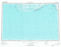
1954 Map of Kuskokwim Bay
USGS Topo · Published 1977About this map
Kuskokwim Bay dominates this coastal survey, where the river systems of the Yukon-Kuskokwim Delta meet the Bering Sea. The landscape is characterized by an intricate network of tundra lakes and tidal flats, including Bow Lake and Kolekfikpuk Lake, protected within the Clarence Rhode National Wildlife Range (Area No 2). Settlements like Kwigillingok and Kongiganak are positioned along the southern coast, where a Seaplane Anchorage and a coastal Winter Trail suggest the essential role of seasonal transport in this roadless environment. Further west, Cape Avinof serves as a prominent landmark near the Etolin Strait, while the eastern portion of the map details the complex maritime navigation through the Kuskokwak Channel and West Channel near Warehouse Bluff.
Find a feature on this map
33 named features on this map. Tap any name to fly to it.
Don’t see what you’re looking for? This feature index may not catch every label — zoom into the map to look around manually.
Map Details
Editions of this 1954 Kuskokwim Bay Map
3 editions found

Other maps of this area

1950 · Bethel
USGS Topo · 1:250,000

1950 · Hagemeister Island D-6
USGS Topo · 1:63,360

1951 · Kuskokwim Bay
USGS Topo · 1:250,000

1951 · Cape Mendenhall
USGS Topo · 1:250,000

1951 · Nunivak Island
USGS Topo · 1:250,000

1951 · Goodnews
USGS Topo · 1:250,000

1951 · Hagemeister Island
USGS Topo · 1:250,000

1951 · Baird Inlet
USGS Topo · 1:250,000

1952 · Cape Mendenhall
USGS Topo · 1:250,000
1953 · Kuskokwim Bay D-2
USGS Topo · 1:63,360