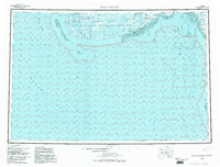
1954 Map of Kuskokwim Bay
USGS Topo · Published 1983About this map
Kwigillingok and Kongiganak anchor the coastal landscape of this mid-century survey, situated where the tundra meets the tidal flats of the Yukon Delta National Wildlife Refuge. The map details a complex network of waterways, including the Kuskokwak R and the Ishkowik R, which define the intricate delta drainage into Kuskokwim Bay. Evidence of seasonal movement and remote infrastructure is found in the Winter Trail and a solitary Landing Strip near Chalit.
Find a feature on this map
28 named features on this map. Tap any name to fly to it.
Don’t see what you’re looking for? This feature index may not catch every label — zoom into the map to look around manually.
Map Details
Editions of this 1954 Kuskokwim Bay Map
3 editions found

Other maps of this area

1950 · Bethel
USGS Topo · 1:250,000

1950 · Hagemeister Island D-6
USGS Topo · 1:63,360

1951 · Kuskokwim Bay
USGS Topo · 1:250,000

1951 · Cape Mendenhall
USGS Topo · 1:250,000

1951 · Nunivak Island
USGS Topo · 1:250,000

1951 · Goodnews
USGS Topo · 1:250,000

1951 · Hagemeister Island
USGS Topo · 1:250,000

1951 · Baird Inlet
USGS Topo · 1:250,000

1952 · Cape Mendenhall
USGS Topo · 1:250,000
1953 · Kuskokwim Bay D-2
USGS Topo · 1:63,360