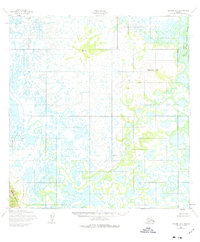
1952 Map of Kwiguk A-5
USGS Topo · Published 1977About this map
Ingrichuak Hill rises above a vast expanse of wet tundra and intricate waterways in this mid-century mapping of the Alaska wilderness. The landscape is defined by the shifting course of the Ponglevik River and the broad Slough Tunurokpak Channel, reflecting a highly dynamic fluvial environment where land and water frequently merge. Near the southern edge, the Kusilvak Mountains provide a rare point of elevation in a territory dominated by low-lying drainages like the Black R and Igrikchuk. Surveyed just after the war using aerial photography, the map includes established benchmarks such as VABM 389 Army, which served as critical control points for the Army Corps of Engineers in this remote region.
Find a feature on this map
8 named features on this map. Tap any name to fly to it.
Don’t see what you’re looking for? This feature index may not catch every label — zoom into the map to look around manually.
Map Details
Editions of this 1952 Kwiguk A-5 Map
2 editions found
Other maps of this area

1951 · Marshall
USGS Topo · 1:250,000

1952 · Kwiguk
USGS Topo · 1:250,000

1952 · Kwiguk A-5
USGS Topo · 1:63,360

1952 · Kwiguk B-6
USGS Topo · 1:63,360

1952 · Kwiguk A-6
USGS Topo · 1:63,360

1952 · Kwiguk B-5
USGS Topo · 1:63,360

1952 · Kwiguk A-4
USGS Topo · 1:63,360

1952 · Kwiguk B-4
USGS Topo · 1:63,360
1952 · Marshall D-7
USGS Topo · 1:63,360

1952 · Marshall D-6
USGS Topo · 1:63,360