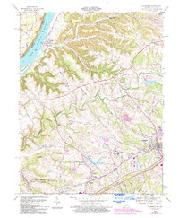
1969 Map of La Grange
USGS Topo · Published 1994About this map
The Ohio River forms the western boundary of this Kentucky landscape, where the riverbank community of Westport serves as a historic point of entry. Moving inland, the terrain transitions into a series of prominent ridges and hollows, such as Covington Ridge and Garrett Ridge, which dictate the local road network. The map reveals a mix of institutional and civic development during the late 20th century, notably the sprawling State Reformatory complex and the County Fairgrounds near La Grange.
Find a feature on this map
57 named features on this map. Tap any name to fly to it.
Don’t see what you’re looking for? This feature index may not catch every label — zoom into the map to look around manually.
Map Details
Editions of this 1969 La Grange Map
4 editions found
Other maps of this area

1905 · Prospect
USGS Topo · 1:62,500

1912 · Prospect
USGS Topo · 1:62,500

1932 · La Grange
USGS Topo · 1:62,500

1938 · Owen
USGS Topo · 1:24,000

1939 · Bethlehem
USGS Topo · 1:24,000

1948 · Bethlehem
USGS Topo · 1:24,000

1948 · Owen
USGS Topo · 1:24,000

1951 · Anchorage
USGS Topo · 1:24,000

1951 · Crestwood
USGS Topo · 1:24,000

1953 · Bedford
USGS Topo · 1:24,000