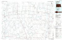
1986 Map of La Moure
USGS Topo · Published 1986About this map
Whitestone Battlefield State Park stands as a significant historical landmark in this region of North Dakota, preserving the site of an 1863 conflict. During the mid-1980s, this area was defined by a dense grid of township boundaries such as Pomona View, Golden Glen, and Black Loam, reflecting the late-century agricultural organization of the Great Plains. The landscape is heavily influenced by the James River and its accompanying James River Valley, which support several conservation areas including the Dakota Lake National Wildlife Refuge and Cottonwood Creek State Recreation Area. Large regional hubs like La Moure, Oakes, and Ellendale are connected by a network of heavy rail including the Soo Line and Burlington Northern. Small prairie settlements like Monango, Berlin, and Fullerton dot the landscape, often situated near small reservoirs and dams such as the Wilson Dam or Jolin Dam.
Find a feature on this map
130 named features on this map. Tap any name to fly to it.
Don’t see what you’re looking for? This feature index may not catch every label — zoom into the map to look around manually.
Map Details
Editions of this 1986 La Moure Map
2 editions found
Other maps of this area

1894 · Monango
USGS Topo · 1:62,500

1894 · La Moure
USGS Topo · 1:62,500

1894 · Ellendale
USGS Topo · 1:62,500

1894 · Hecla
USGS Topo · 1:62,500

1894 · Savo
USGS Topo · 1:62,500

1894 · Fullerton
USGS Topo · 1:62,500

1894 · Oakes
USGS Topo · 1:62,500

1895 · Lamoure
USGS Topo · 1:125,000

1896 · Columbia
USGS Topo · 1:125,000

1896 · Jamestown
USGS Topo · 1:125,000