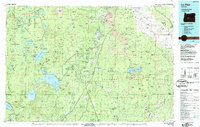
1986 Map of La Pine
USGS Topo · Published 1987About this map
Wickiup Reservoir and Crane Prairie Reservoir dominate the central basin of this mid-1980s landscape, illustrating the critical water management systems of the upper Deschutes River. The map reveals a transition from the volcanic peaks of the Three Sisters Wilderness, including Mount Bachelor, to the eastern lava flows of Newberry Crater and Horse Ridge. Transportation and timber history are intertwined along the north-south corridors of the Burlington Northern and Southern Pacific railroads, which served the established timber-related settlements of Gilchrist and La Pine. Extensive scientific and conservation boundaries are clearly delineated, including the Pringle Falls Experimental Forest and the La Pine State Recreation Area, showing a region balanced between industrial forestry and emerging recreational development in the high desert transition zone.
Find a feature on this map
125 named features on this map. Tap any name to fly to it.
Don’t see what you’re looking for? This feature index may not catch every label — zoom into the map to look around manually.
Map Details
Editions of this 1986 La Pine Map
2 editions found
Other maps of this area

1917 · Diamond Lake
USGS Topo · 1:125,000

1925 · Waldo Lake
USGS Topo · 1:125,000

1926 · Bend
USGS Topo · 1:125,000

1929 · Bend
USGS Topo · 1:125,000

1929 · Three Sisters
USGS Topo · 1:125,000

1930 · Maiden Peak
USGS Topo · 1:125,000

1931 · Newberry Crater
USGS Topo · 1:125,000

1932 · Three Sisters
USGS Topo · 1:125,000

1934 · Maiden Peak
USGS Topo · 1:125,000

1934 · Mc Kenzie Bridge
USGS Topo · 1:96,000